
The lands and countries of Ghelu are mostly defined out of the very long-termed language of the Budmen who mythically taught the Mankind. The local names can vary significantly due to dialects and changing leaders, the definition of the more long-lasting regions however have basically stayed the same for thousands of years. The old Ansu terms have found their way into the language of the Semier.
![]()
Disclaimer: The words and especially names are freely invented by me out of various reasons. I have written several words in bold font to distinguish them from the „normal“ world. Those bold font words descripe something inside the world I am creating here and have thus no direct connection to reality. I hope this clears any misunderstanding up front. Best example would be the word manic, which originates from the term Mane or Manes, describing a human in my world, not a real life term about a mental condition.
![]()
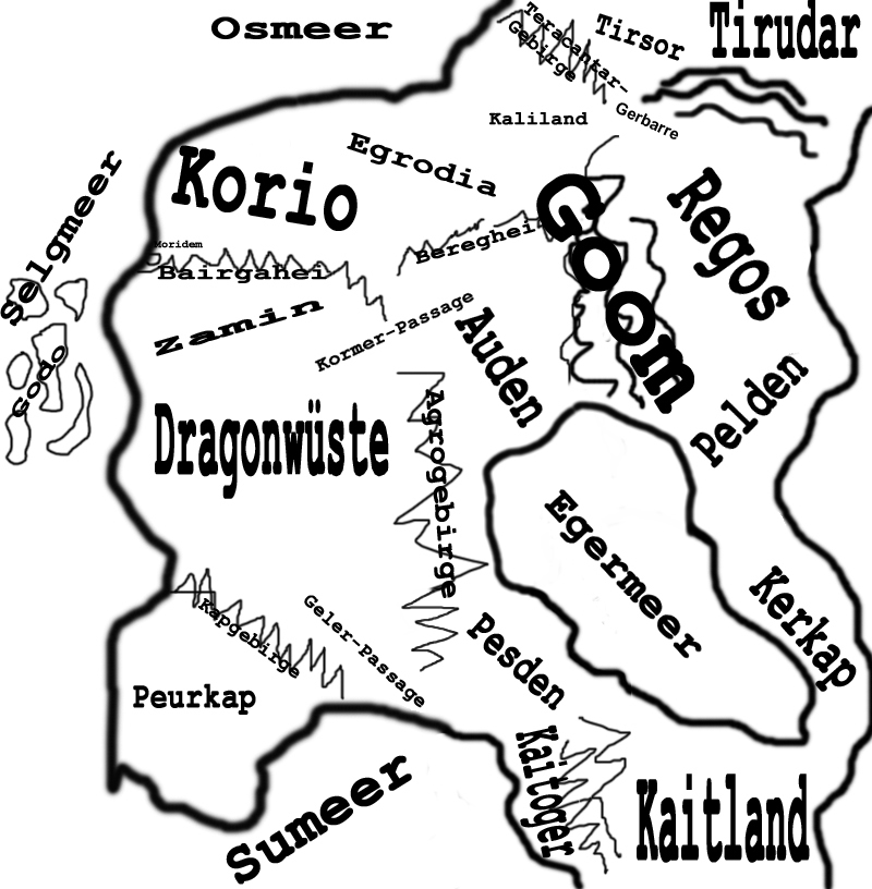
Harland
Probably originating from the Budmen word “Karland” which means “hard land”. The Ensani call it “Tokhzamin” (Core Land), the Semier “Tir Teacht” (Land of the Arrival) and the Daomin and Xiaomin “Tu Hei Long” (Land of the Evil Dragon). Formerly the Budmen defined the world south of the Ansu and north of the woodlands as the Karland. Now the word Harland has been mostly changed to describe the land between the Osian Sea, the Selgian Sea, the Eger Sea and the countries Goom and Tirsor. If the whole continent is described, it is often called “Greater Harland”.
![]()
Osian Sea (Osmeer)
The Osian Sea is the great sea that stretches from Harland far into the north. The name originates from the Egrodian term of “Ozhmare” and the Budmen word “Osmor”, both meaning “far sea”. The Ensani call it “Dawdarya” and the Daomin and Xiaomin “Ming Liao” (Distant See), the Semier term is “Muir Mor” (Great Sea). While the coast of Harland is mostly cartographed and used as trading areas, the north is rumoured to be very unsafe and only passed by the most courageous captains. Since sailing around the Tirudar would take much longer than the direct trading routes along the relatively safe borders of the Goom, there is also hardly a reason to do so. The mythical island realm of Senoland is said to have sunken into the Osian Sea 12.000 years ago.
![]()
Selgian Sea (Selgmeer)
The name for the great sea in the west of Harland is originated from the Budmen word “Selgmor” (Free Sea) and the Egrodian word “Selgmare”. The Semier call it “Muir Saor” which basically has the same meaning. The Ensani describe it as “Badarya”, the “Evil Sea”, while the Daomin and Xiaomin just call it “Ming Long” (Dragon Sea). The island realm of Godo lies in the Selgian Sea off the coast of Zamin, and the dangerous trip west leads to the homeland of the Xiaomin, Peurden. The great trade city of Moridem lies at the shores where the Aser flows into the Selgian Sea, and the coast is used widely for trading with the southern regions since land routes along the Dragon Desert are always an unsafe situation.
![]()
Eger Sea (Egermeer)
The Eger Sea is named after its location. Due to the fact that it's the only sea with direct connection to the Goom and the fact that it has no connection to the outer oceans, the Budmen call it “Egheromor”, which means “Inner Sea”. The Egrodian term is “Egemare”. The Eger Sea lies within Harland and stretches from the more gentle shores of Auden along Pesden, Pelden and Kerkap down to the cliffs of the Kaitoger mountains and the woodlands of Kaitland. Although it can become extremely hot at crossings, it's the most popular trade route to the Southeast, since there are hardly any other threats than the heat. The Ensani thus call it “Khubdarya” , the “Good Sea”, the Semier named it “Muir Siochan”, “Sea of Peace”, and the Budmen have a second name for it, “Tausmor”, which means “Peaceful Sea”. Since Daomin and Xiaomin hardly ever reach these calm shores and have to fight with the much more unsafe Selgian Sea, their term is “Ming Chuan Shuo”, the “Sea of Myth”.
![]()
“Death Sea” (Nekromeer)
The term for the most eastern sea of Greater Harland is originated from the Egrodian term “Necromare”, which means “Sea of Death”. While the Budmen term seems to warn from it by calling it “Memor”, the “Sea of Nothing”, and the Daomin and Xiaomin call it “Ming Quing Long”, the “Sea of the Young Dragon”, the Semier strangely named it “Muir Baile”, the “Homesea”. The Death Sea stretches from Tirudar all the way down to Kaitland, and although it is rumoured that it would offer a quicker passage to the homeland of the Xiaomin to the east (thus proving the widespread opinion of a round world), nobody has ever travelled over it and returned to tell the tale. The Death Sea is by far the most dangerous sea around Greater Harland, most mythical creatures including sea dragons and gigantic Maelstroms are placed in it, and even the trade fleet of Regos tries never to lose sight of the shore while running down to Pelden and the Kerkap. The further south, however, the calmer is the travel.
![]()
Surian Sea (Sumeer)
The “Sudarya” of the Ensani gave the Surian Sea its name. This term of the “silent sea” has also found its way to the Egrodian language, where it's called “Silenmare”. The Semier call it “Muir Laidir”, which means “Strong Sea”, the Budmen “Suimor” (The Disappearing Sea) and the Daomin and Xiaomin “Ming Lu Long”, the “Sea of the Green Dragon”. The Surian Sea reaches from the Southwest of Harland and its Peurkap to the east until reaching the cliffs of the Kaitoger mountains northwest of Kaitland. Since the Geler Passage leads directly into the Dragon Desert, most trades are made through Pesden, making it the only part of Harland at two relatively calm shorelines.
![]()
Kaitland
The homeland of the Sulkel lies south of Greater Harland and although connected to it is not added to it in most definitions. The term yet again is of Budmen origin, their word “Kaitoden” meaning “Woodland”. The Daomin and Xiaomin claim it to be “Go Lu Long”, the “Realm of the Green Dragon”, while the Semier describe it as “Coill Alainn”, the “Beautiful Forest”. The Kaitland probably stretches extremely far into the south, however most travels end at the northern shores since the Sulkel dislike travellers in their heartland. Expeditions by ship along the eastern and western shores have revealed not only that there is no short passage, but also have led to the claims that Kaitland is larger even than Greater Harland.
![]()
Egrodia
The core land between the Goom in the Southeast, Bhereghei in the South, the Osian Sea in the North, the Kaliland in the Northeast and Korio in the West is the origin of the Lendmanes and continues to be the part of Harland with the most active history. Although being controlled by the Egrodian Empire for a very long time now, there has always been trouble especially along the northwestern borders which connect to the semi independent Kaliland and the totally uncontrollable Gerbarre. The name Egrodia originates from a Lendmanic tribe of the same name that probably claimed it about 4.000 years ago.
![]()
Goom
While Egrodia might be the land with the most active history, Goom surely is the one of the utmost importance. The homeland of the Budmen lies between the Kaliland, Egrodia, Korio, the Bairgahei Mountains, Tirsor and Bheregi and connects with some lowlands and meadows to the Eger Sea. Goom itself is extremely mountainous and secluded. It is said that over the centuries and millennia of its existence the Budmen have barred and fortified every possible passage way, making it completely unconquerable. However it is a fact that most never see the Goom in their entire life and that every Budmen wants to travel to the court of the Mountain King ruling the land at least once. Anybody of Semian or rumoured Ansu origin is barred from ever entering Goom.
![]()
Kaliland
The borderland between the Budmen, the Manes and the Semier lands is called “Tir La”, the “Land of Day”. It borders Egrodia in the West and nowadays is a vassal kingdom to it. The Teracantar Mountains in the North, Tirsor in the Northeast, Goom in the Southeast and especially the Gerbarre in the East make it a very unfriendly land to live in. Apart from the western cities and the trade routes along the border of Goom, most of Kaliland is unguarded and with rural structures of law and order at best. While being a minority in the Western parts of the land, the Semier have the majority in total and see Kaliland as their own, much to the disagreement of the Egrodian Empire and the Vassal King.
![]()
The Teracantar Mountains (Teracantar-Gebirge)
This widespread area of high mountains along the border of Kaliland seperates it from the new homeland of the Semier, Tirsor. The name is a malapropism of the term “Teorainn Ceantar”, which means “border region”. Few passes lead through the Teracantar Mountains, and since the Tirsor is no place to make good deals, the Semier are mostly the only ones who travel them.
![]()
Tirsor
The “Tir Sor” (“Free Land”, but also “vacant land” and “cheap land”) is the wilderness east of the Teracantar Mountains, North of Kaliland and Goom. It is inhabited by Semier and also gives refuge to several tribes of Guermen and Uorg, Orbo and whatever else cannot find a steady place within the borders of the manic lands. There are at least two well-known trade routes which are heavily guarded by Semian troops, and the only larger settlement known is Kaschant (“Caislean Teith”, the “Castle of Escape”), founded short before the Mage Wars.
![]()
Tirudar
The “Tir Udar” is the “land of origin” for the Semier, however they claim it to be the land of origin of the mythical Ansu. It lies North and Northeast of Tirsor and there is a high probability that no-one other than a Semier ever set foot in it and lived to tell the tale. Even amongst Semier the Tirudar is center of myths and storytelling, and there are no known trade routes or settlements. If the Ansu survived to these days, they must live there.
![]()
The Gerbarre
This wild stretch of land North of the Goom, East of Tirsor and South and Southeast of Tirudar has its origins from a war that rendered it inhabitable for centuries due to magical influences, probably caused by Mages of Regos. Nowadays the area is mostly uncharted and unsettled but supports a high population of Uorg. The fact that this must always have been a violent land is deducted from the Semier name for it, “Tir Anbhas”, which means “Land of Violent Death”, which is also the most common cause of death here.
![]()
Regos
The Magocracy of Regos (Magokrat Regos) is considered the darkest of lands ever created by Manes. The name probably originates from the Budmen word “Regoden”, which means dark land. The Ensani call it “Zamin Tarik”, which has the same origin, while the Semian term for it is “Tir Geal”, the exact opposite, meaning “Bright Land”. The Daomin and Xiaomin term is “Guo Hui”, “Incomprehensible Land”. Regos lies between the Tirudar in the North, the Gerbarre in the Northeast, Goom in the East and Pelden in the South and thus always had trouble with trading routes as well as sea travel over the Death Sea. While most countries are rules with at least a little tolerance, the laws of Regos are the harshest of them all. The royal family claims to be descendant of Mar Aga, the “First Mage” or “True Mage”, who probably also caused the Mage Wars. It is a fact that the members of the Magocracy are the only ones openly trying to practice Soito (under the term “Magic”) amongst all Manes, call their followers “Mages”, also have founded and supported the only existing Mage Academy, and thus are unpopular amongst all other societies. While most think that all “Magic” consists of illusions and tricks, Regos has built an aura of fear with it that protects them especially from the Uorg in the bordering Gerbarre.
![]()
Pelden
The “Sold Land” according to the Budmen term of the same name describes the region between Regos in the North, Goom in the Northeast, the Eger Sea in the Southeast and the Kerkap in the South. While being densely populated in the northern parts, it is deserted in the south due to the extreme climatic situation, however still passable compared to the Dragon Desert. While Regos has its eyes on Pelden for centuries since its blocking the direct trade over the Eger Sea for them, the country is under protection of Goom, which makes it quite stable. The Ensani call it “Zamin Jannasa”, “Similar Land”, while the Semier term “Tir Seilg” means “Hunted Land”. The Daomin and Xiaomin focus on the trade revenues, calling it “Guo Fu”, the “Rich Land”. Pelden's society is so much embossed by the trades that it is rumoured “anything in it is just a matter of coin”.
![]()
Kerkap
The dark cliffs of the eastern shore towards the Death Sea probably gave the “Kerskap” its name. The Budmen term describes it as “Black Coast”, as does the Ensani term “Sahel Siyah”, the Semian “Costa Dubh” and the Daomin/Xiaomin “An Wu”. Kerkap lies between the Eger Sea in the east, Pelden in the North and Kaitland in the South and is mostly uninhabited. There are a few trade routes, but most travel goes over the Eger Sea or along the Dead Sea coast which here is dominated by the before mentioned black cliffs that make a docking a gamble. Kerkap is known as a retreat for cutthroats, slave merchants and otherwise shady beings since there is no rule of law and no Uorg to bash their heads in like in other parts of Greater Harland.
![]()
The Bereghei Mountains
Homeland of the Beregmanes, the Bereghei Mountains or simply Bereghei is now under Guermen control. Northwest of the Goom, southeast of Korio and south of Egrodia it is a well-known retreat for the “Barbarii” and most trade and travel tries to widely avoid it.
![]()
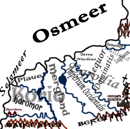
Korio
The plainsland west of Egrodia, north of the Bairgahei Mountains and Moridem and bordered by the Osian Sea in the North and the Selgian Sea in the East has undergone a vast development in the last hundred years. It is named after Korus who brought the land independence with his sensible alliances to other lands and his victory at the Battle of Katla, in which he was killed. Korio still is reigned by a Praetor (Praetorrealm Korio), this however being the last remnant of the former Egrodian control. The country is considered to be one of the three richest of the world, following Egrodia and Zamin. Its inhabitants are called Kori.
![]()
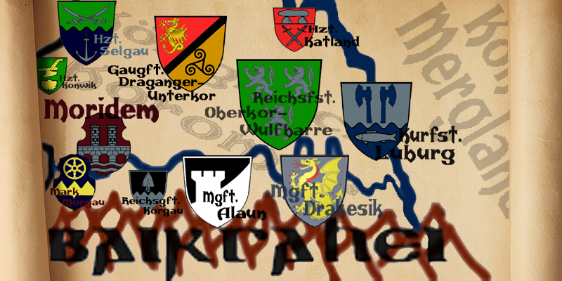
Moridem
Although not amongst the oldest cities of the world, Moridem is the most famous. The again-independent city state at the Northwestern border of the Bairgahei and southwest of Korio is the by far most important port of the Selgian Sea, if not the whole world. Anything can be bought and sold here, and while it remains at least a little self-sufficient with the agricultural Mark Morgau in the south belonging to it, its profits are solemnly due to trade. Moridem is the richest city of the world as well as one of the few that is ruled by a council. The river Aser runs right through Moridem, opening shipping routes deep into Korio, and the city's naval architecture is unrivaled. Outside of the Goom Moridem also has the best craftsmanship and a blade with the stamp of a Moridem forge is among the most expensive throughout Greater Harland.
![]()
The Bairgahei Mountains
As a border to the northern lands, the mountains of the Bairgahei are mostly inhabited by Guermen and Beregmanic tribes. While being the origin of several attacks and small wars in the past, nowadays most feuds are fought within each other. The trade of lumber for Moridem is by far the greatest income for the inhabitants and there are several trade posts within the Bairgahei that are, however rough and violent, relatively safe.
![]()
Zamin
The Sultanat Zamin, full name “Zamin Mubarak” given by the local Ensani inhabitants and also called “Samant” in other parts of the world, is the rich land north of the Dragon Desert and south of the Bairgahei Mountains. Although under occupation during several periods of its existence, the land is one of the oldest manic societies and has had a very high cultural development ever since. Called “Tir Tirim” (Dry Land) by the Semier and “Samland” by the Budmen, Zamin not only has several extraordinary buildings and architectural marvels but also about the best gold and silver craftsmanship of Greater Harland. The constant threat of Korosi and the sometimes horrible summers with dust storms and dry periods coming from the Dragon Desert has lead to a society where “every man and woman must be able to hold a weapon and survive in the desert”. Although the northern lands would probably never admit it, Zamin also has the most advanced position on gender equality and the highest per capita education of all manic lands.
![]()
Dragon Desert (Dragonwüste)
The “Wadi Dragon”, called like that by its only manic inhabitants, the Ensani in the north, is probably the most life-hostile area of the world. The Semier call the Dragon Desert “Fasach Dragan”, the Budmen “Dragoland”. While the plains and brushland at the northern and western borders aren't all that bad, the desert itself is murderous. South of the Bairgahei, west of the Agro Mountains and north of the Kap Mountains, there is nearly no rain, the suns are torching the place and several large parts are without any vegetation or life. The only ones who can travel deep into the Dragon Desert are the Korosi, which also is the only reason why this violent species of lizard people has yet escaped any try to finally end their threat on the manic settlement at the borders.
![]()
The Agro Mountains (Agrogebirge)
West of the Eger Sea, south of the Goom and the Kormer Passage, north of the Geler Passage and the Kap Mountains lies a long stretch of red-yellow mountains that borders the Dragon Desert from more inhabitable areas. If there is any population within these mostly rainless mountains, they must lead a harsh life. All trade just goes directly through the Passages or over the seas.
![]()
The Kormer Passage (Kormer-Passage)
These Highlands between the Bairgahei in the North, the Agro Mountains in the South, the Goom in the East and the dreaded Dragon Desert in the West are the best way to get trade from Egrodia or Auden to Zamin. Several old fortresses guard the way, making it about the only safe inland passage along the Dragon Desert. Most trade from Korio goes by ship over Moridem.
![]()
The Geler Passage (Geler-Passage)
This is a lowland between the Agro Mountains in the North, the Kap Mountains and the Peurkap in the South, the Eger Sea in the East and the Dragon Desert in the West. While being a possible trade route to the Peurkap, most merchants would be insane to take it, since the passage over the Surian Sea or the Eger Sea is much safer and comfortable. At least it rains here now and then, making it a comfortable place compared to the nearby desert.
![]()
Auden
If there is a place that is the perfect retreat for the weary, Auden is the one. The stretch of land between the Agro Mountains, the Goom, the Kormer Passage, the Eger Sea and the Bereghei is rich on vegetation, wildlife and especially water. Being under the protection of Goom where it delivers most of its agricultural production has made Auden a safe haven, and the fact that it is surrounded by so many mountains makes it a climatically comfortable land as well. In consequence Auden has become about the first and only part of Greater Harland that is visited for recreational purposes.
![]()
Pesden
The importance of this coastal country between Eger Sea, Surian Sea, the Geler Passage and the first parts of the Kaitoger Mountains as a trading way is unmatched. Here lie the land routes between the Surian Sea and the Eger Sea, here you can get lots of products from Regos and Kaitland alike, and the havens are quite safe. Pesden is about the manic country with the highest population of Sulkel.
![]()
The Kap Mountains (Kapgebirge)
South of the Dragon Desert, North of the Peurkap, the protective border for the latter. Scarcely inhabited, however not as uncomfortable as the Agro Mountains.
![]()
Peurkap
The coastal lands of the Southwest have access both to the Selgian and the Surian Sea, which is the reason why they were explored and developed by the northern manic settlers. The most important port for trips to the South and Southwest, as well as for incoming and outgoing merchandise from and to Pesden. Nominally still a vassal kingdom to the Egrodian Empire, however basically independent since its most important trade location is Moridem.
![]()
The Kaitoger Mountains
They border Pesden in the North, Kaitland in the South, the Surian Sea in the West and stretch up to the Death Sea in the East. While many shipments go around it using the Eger Sea, a passage through the Kaitoger is still a good way to shorten a trip. Also an important resource for lumber for the Pesden shipyards.
![]()
Gheland
A rumoured country in the south, which is cold and mountainous, with many belts and wiks. The Morimanes, also known as Skures, a folk of traders and sailors, originates from here. The most likely way to get a passage or at least meat a Skure is a port tavern in Peurkap.
![]()
Peurden
The manic name for the continent in the West behind the Selgian Sea where the most daring captains sail to get enough money from a single shipment to live from it all their life. The Daomin call it “Go Huo”, the Xiaomin “Di Go Huo”.
![]()
Godo
These islands in the Selgian Sea off the shores of the Dragon Desert and Zamin are named by the Daomin and Xiaomin: “Go Dao”. Formerly controlled by the northeastern Manes, they were settled by the incoming people from the western continent of Peurden. In Moridem exists a large settlement of people who have very good contacts with Godo, and the city is about the only place that can import goods from there in larger quantities.
![]()
 |
||||
 |
 |
 |
||
 |
 |
 |
|
 |
 |
|
 |
||
 |
![]()
